Introduction
The functions of governance and administration of any country are based on the constitutional mandates that were defined several years, and in some cases, decades ago. Over time, Governments around the world have been forthcoming in the adoption of newer policies and enabling technologies.
But as the World powers forward in terms of technology advances for the masses, it is only right and necessary for the Governments of the World to stay abreast. We already see a shift in the way the internet is controlled and consumed with Web 2.0 & blockchain technology – it will not be too long before citizens lose confidence in the constructs of governance that exists today.
Governments should not only be looking at adopting cutting-edge technologies that can assist in the way they function but should also be willing to leverage public data to offer better governance to their citizens & constituents. Governments need to look at adopting technology that enables citizens to be more responsible about the data and the governance of the country. For example, Google’s map data is based on existing users’ location data – this handshake enables Google to offer accurate data that is leveraged to the fullest by its users. Google users see their inbuilt responsibility to contribute to this intricate balance, as it benefits them to provide location data whenever & wherever they can.
Geofencing is one such technology that can be leveraged by Governments for better governance and administration. We will be exploring the possibilities this technology offers governments to deliver location-based services for efficient public service delivery.
The basics of Geofencing technology
Geofencing is a GPS or RFID-based location tracking and management technology that allows entities to create virtual boundaries around a particular pin on a map. Using this technology, leveraging entities can manage the interactive elements, namely mobile devices in a certain network, or GPS-enabled vehicles or drones, within the virtual boundaries defined by the Geofence.
The future of Geofencing technology is surreal and it leverages GPS, RFID, and cellular or WiFi technologies on mobile devices to geolocate individual assets in a network within pre-defined boundaries. The entity deploying the technology sets up polygonal geofencing concepts to define the virtual boundaries of operation of the geofence – assets or controls within the boundaries are then monitored & manipulated to achieve a certain set of results.
The applications of this technology for governments
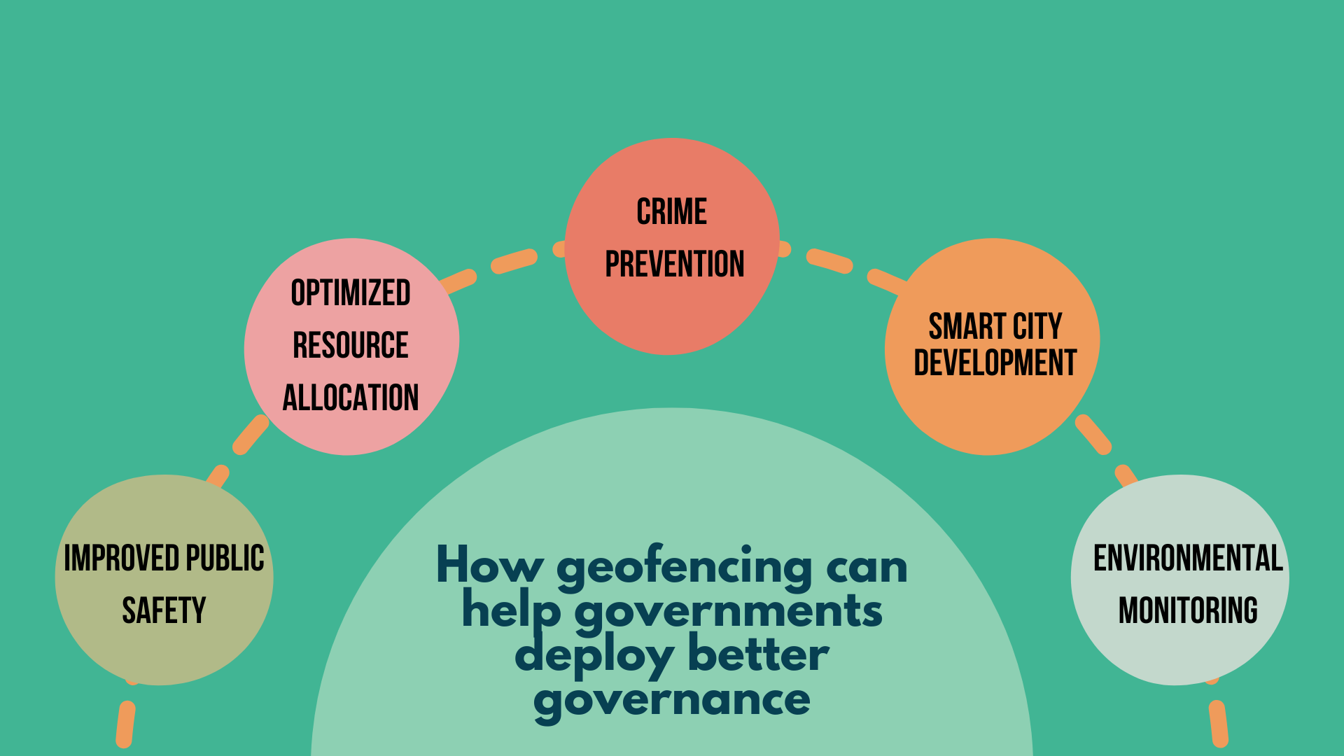
Governments can leverage geofencing technologies and location-based services to manage cities and citizens better. A wide range of applications is possible including Public service delivery, Environmental monitoring, Infrastructure management, Disaster & emergency management, Resource allocation & optimization. Governments can look to Data-driven decision-making with geofencing technology for improved public safety and smart city development.
Below are some possibilities for better governance explained in detail:
Governance
Government organizations can improve the overall operational efficiency of the city by integrating geofencing into citizen management protocols. These systems can effectively be modernized to adapt to real-world situations at speed and scale.
Traffic management
By creating a complex set of geofences that connect all the roads of a city or region, the respective department would be able to assess the traffic load in real-time within these geofences and dynamically control and regulate traffic signals and flow based on demand.
Push notifications
Similar to traditional geofencing-based marketing push notifications employed by several organizations worldwide, government departments can efficiently and seamlessly push notifications to citizens’ cell phones about services or news within the geofence.
This also creates the opportunity for Multi-department integrated administrative alerts. For example, in a democratic country, where polling is necessary, the government can push notifications to the voters’ phones basis their need to complete their civic duties.
Emergency situations
Emergency Response
Geofencing technology in crime prevention and emergency response could be a major application, as it would allow organizations to gain absolute visibility and control of zone-wise emergency operations.
By controlling traffic flow, the government would be able to allow emergency response teams such as ambulances or firetrucks to have right of way even in high-traffic zones.
Additionally, governments will also be to monitor and control activity within an active crime zone or crime-prone zones, in order to mitigate or nullify the damage that such criminal activities could engender.
COVID & other pandemic / endemic control
In several countries, including certain states in India, geofencing was used effectively to monitor the movement of infected and non-infected individuals during the COVID crisis.
Similarly, geofencing can be deployed in future situations akin to the events of 2020, and mitigate the spread of disease.
Earthquakes in Turkey
The 2023 earthquakes in Turkey and Syria have been devastating and saw survivors trapped under the rubble for over a week since the first quake. In situations like these, makeshift radio towers can be installed in affected areas to create geofences and track survivors, enabling the government to deploy effective resource allocation.
The cons of Geofencing
The potential of geofencing in administration and law enforcement can be directly seen as the downfall of the system. This can easily be considered to be the system’s biggest flaw.
Although governments can deploy geofences to provide better protection and services to their citizens, it can also be construed as a violation of citizens’ civil liberties and rights.
In fact, in a bank robbery case that has been going on since 2019 in the United States, a Federal judge ruled against the use of geofencing technology to investigate the crime scene, as according to her, the investigation had violated citizens’ privacy and civil liberties.
Although this might seem like a clear red flag against the use of geofencing, proponents of the technology believe that there is still a lot of potential for law enforcement, with the right policies in place.
Conclusion – Finding the right partner
This may be one of the foremost reasons you may need someone who is more than just a technology provider to develop a robust and empathetic solution based on geofencing. You need an implementation partner who takes on a consultative approach to the problem and works with the government department to deploy a solution that is both effective and empathetic, benefitting all parties involved.
This also necessitates the need for prior expertise in implementing a similar solution. ManageTeamz is a comprehensive delivery tracking management system that deploys geofencing technology to manage fleets and assets for its clients. ManageTeamz boasts a ready-to-deploy POC that can be retrofitted to the needs of the government department.
Talk to our experts today to learn more about ManageTeamz and geofencing technology for better governance and administration.
Like what you’re reading?
Get on a free consultative call with our team of industry experts to explore the possibilities on the subject.